Mexico City Benito Juarez International Airport (MEX)
Orientation and Maps
(Mexico City, Mexico)
A sprawling city made up of more than 300 different neighbourhoods, Mexico City is known locally as the 'Ciudad de México'. Covering a vast area, Mexico City may be enormous, but it is usually fairly easy for visitors to find their way around.
Just minutes to the east you will find Mexico City International Airport (MEX), the city's busy transport hub, where a steady flow of tourists arrive year round. Major streets around the city keep their name for many miles, such as the Avenida Insurgentes, although smaller roads tend to change name every two or three blocks. When looking for a particular address, the most simple way is often to ask for a nearby Metro Station as a point of reference.
Mexico City International Airport (MEX) Maps: Important City Districts
The city's true historic centre is full of attractions and is based around the Zócalo plaza, with both the cathedral and presidential palace being located nearby. This area of Mexico City features an especially rich heritage and is known as the 'Centro Histórica', containing many old and eye-catching buildings, together with a number of notable museums. Nearby you will find plenty of cheap hotels and popular restaurants.
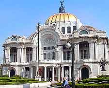
The Alameda Centre park is located on the western side of Mexico City and is linked to the city by both the Avenida 5 de Mayo and the Avenida Madero. To the east, the Palacio de Bellas Artes dominates much of the area, with is grand architecture and topiary gardens. To the south, the Latin American Tower has become an important part of the skyline.
Mexico Map

Mexico City Map

